CityCyclingEdinburgh Forum » Infrastructure

Newcraighall consultation event Friday 3 September 2010 (Brunstane developments)

(85 posts)
  • Started 13 years ago by Cyclingmollie
  • Latest reply from Cyclingmollie

  1. Tulyar
    Member

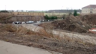
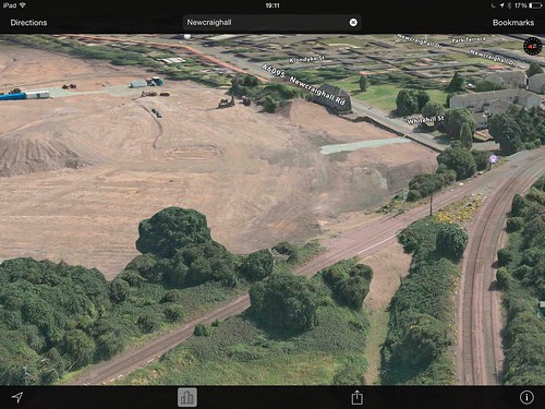
    Of course there is a greater value in keeping the continuity of a railway route wayleave. The cycle path from Elderslie (actually from Paisley Canal for some of it) to Kilmacolm also carries Scottish Power telecontrol cabling, and a fibre optic trunk route, both of which provided support in cash and/or kind for the cycle route, and saved the owners of the cable a substantial sum and major delays which would have arisen if they had had to lay their cabling in the A761 200-400 metres at a time with traffic controls.

    In preserving the old rail lines network Edinburgh has (had - opinions may vary) a great resource which could even permit rail re-use if required, noting that with a robust position it is possible to deliver a restored rail route, and a realigned cycle route, especially if light rail, electric 'trains' are used, with their ability to handle steeper gradients etc.

    Getting all potential allies on-side can provide a key way to keep the 'transport corridor' intact. In retrospect I think that 'selling the potential of the cycle route plus reopened rail line, on the shortest distance between Edinburgh and Glasgow, as a wayleave also for communications and other utilities, might have delivered a faster and better completion of the relocated cycle route.

    That and having a more robust clause concerning the delivery of the relocated cycle route comtemporous with the opening of the new railway.

    Posted 9 years ago #
  2. SRD
    Moderator

    Tulyar, do you think it would be possible to run trams to granton and maintain a decent cycle route along the roseburn path as well?

    I'm skeptical to say the least, but it would be good to know if it is possible.

    Posted 9 years ago #
  3. kaputnik
    Moderator

    The cycle path from Elderslie (actually from Paisley Canal for some of it) to Kilmacolm also carries Scottish Power telecontrol cabling, and a fibre optic trunk route, both of which provided support in cash and/or kind for the cycle route

    I seem to recall a section of the West Highland Way near Drymen is on old railway and carries some of the water main for Glasgow under it from Loch Katrine.

    The blurb on the tin of Tennents says how it is brewed from the cool, crystal clear waters of Loch Katrine. That's advertisers longhand for "brewed from tapwater".

    Tulyar, do you think it would be possible to run trams to granton and maintain a decent cycle route along the roseburn path as well?

    The pinch points will be I think under bridges, where it's not possible to widen the trackbed without some demolition work. But to my mind, most of them are pretty generously built regards clearance as they span a fairly wide cutting.

    The trams are "standard gauge" i.e. the rails are spaced the same as on the railway that preceeded them. What I don't know as an enthusiastic layperson is whether or not the loading guage is tighter (i.e. the clearance required around the rails to permit a vehicle to pass unobstructed without hitting anything, in various states of cant). This would mean that the trams could theoretically run closer together and closer to the bridge structures, to leave space for a cycleway alongside. I imagine they'd want to run them straight down the middle of any bridges though, so don't hold your breath.

    The olde tramsse of yore were double deck and had to pass under some pretty low clearance bridges. They did this by lowering the height of the overhead cable but also splaying them out to the side, so that the conductor pole still contacted the wires at an angle.

    Posted 9 years ago #
  4. neddie
    Member

    From Sustrans:

    """
    ...the Newcraighall housing development is moving at a pace, see attached.

    We are concerned that Barratt have now taken over the site from EDI Group. They do not have a good track record in maintaining rights of way or accesses through their sites. Particularly when they are labelling the development as ‘luxury executive housing’.

    You will recall that the land deal for the site included NCN1 being routed through the proposed main street on the ‘new’ path, see pic ‘Newcraighall 01’. You can see that this path still exists for the time being.

    We are asking CEC to insist that NCN1 keeps to the agreed alignment and would be grateful if others could do the same...
    """

    Please write to your councillors if this concerns you

    PS. Barratt has refused to discuss the alignment of the path with us [Sustrans], which again fuels our concern at their intentions

    Posted 9 years ago #
  5. chdot
    Admin

    "see attached"

    Can you post a link?

    "Barratt has refused to discuss the alignment of the path with us"

    What's the problem? Obviously it will be accordance with the detailed planning consent granted by CEC...

    Posted 9 years ago #
  6. amir
    Member

    I cycle past there quite a lot at the moment. I can only imagine the disappointment of the neighbours in Newcraigall.

    Developers are encroaching on green land all around the Lothians now. I was thinking of moving back into Edinburgh but it might actually come out to us now.

    Opposite to Dobbies, they are building another pub on another field. That makes at least 4 new chain pubs in a small area (the one next to the Premier Inn, the one already next to Dobbies and the one at "Shawfair" near to the Park and Ride. No wonder pubs are closing in Dalkeith.

    Posted 9 years ago #
  7. kaputnik
    Moderator

    http://www.bbc.co.uk/news/uk-scotland-scotland-business-28741327

    Barratt Homes has confirmed it is pressing ahead with plans to build 400 new homes in the east of Scotland.

    The builder said it would construct 139 homes at Duddingston Park South, Duddingston, and 165 at Newcraighall Village.

    Barratt Homes will also build a total of 102 affordable homes between the two developments.

    Newcraighall Village and Duddingston Park South are both set to launch later this year.

    Posted 9 years ago #
  8. wingpig
    Member

    Poor bridge. Poor northern abutment.

    Also, poor path, which has been mangled at the edge by the pylon where some heavy vehicles have been playing with piles of rubble.

    IMG_20150228_155507154 by wingpig, on Flickr

    IMG_20150228_155641998 by wingpig, on Flickr

    Posted 9 years ago #
  9. chdot
    Admin

    Yep, another green field gone and (for now) the Right of Way through it -

    This shot shows the stupidity of removing the rail bridge and obliterating the path underneath with a large pile of stones -

    CEC tried to stop this happening, but were unwilling to pay the absurd amount NetworkRail wanted for 'remedial' work and ongoing liabilities.

    Presumable the owners of the new houses would have liked a convenient walking and cycling route to ASDA (and The Innocent into town). No idea if the developers were asked if they might contribute...

    (CEC's own EDI were involved in this site.)

    Posted 9 years ago #
  10. acsimpson
    Member

    Interesting to see that in the picture from that link the bridge still exists.

    Posted 9 years ago #
  11. chdot
    Admin

  12. chdot
    Admin

    "

    Brunstane Green Belt (@Brunstane_GB)
    28/04/2015 08:10
    Petition to save SE #Edinburgh #greenbelt now 8 off 700 supporters. #Portobello #Musselburgh folk pls sign/RT http://bit.ly/SBGB01 #EdEast

    "

    Posted 8 years ago #
  13. Cyclingmollie
    Member

    What is the Second Proposed Local Plan mentioned in the petition?

    Posted 8 years ago #
  14. wangi
    Member

  15. wingpig
    Member

    More NCN1-proximal consultation:

    http://www.portobellocc.org/pccpn/2016/04/16/costa-coffee-drive-thru-at-milton-link-proposal-of-application-notice-1601633pan/

    The site describes the current location of the Range, but the plan drawing includes the underpass from the Innocent and the route across the Range's car park to the bridge to Brunstane station.

    Posted 8 years ago #
  16. chdot
    Admin

    Not being a driverist I can't understand the business model for this. I presume there will be other things for sale, but will there be sit-in space too?

    Apart from the *possibility* of improvements to the walk/cycle route through the carpark I have an overwhelming feeling of 'why bother' - the sheds here have had a wide range of businesses over the years, with (it seems) an increasing rate of turnover/failure(?)

    Posted 8 years ago #
  17. chdot
    Admin

    "

    CAMPAIGNERS battling plans for more than 1000 houses on greenbelt land are threatening to take the council to court.

    The Save Brunstane Greenbelt Campaign (SBGC) said they had taken “initial legal opinion” and had a “very strong case” for challenging development.

    "

    http://www.edinburghnews.scotsman.com/our-region/edinburgh/brunstane-campaigners-seek-legal-advice-on-greenbelt-plans-1-4171402

    Posted 7 years ago #
  18. chdot
    Admin

    "

    Developer EDI – an arms-length council company – wants to construct 1330 houses, a school and leisure facilities over a 48-hectare site known as Brunstane Farmland.

    But community campaigners are gearing up to launch legal action in a bid to halt the proposals – and are now crowdfunding advice from a top QC.

    They argue the overarching South-East Scotland Plan (SESplan) “clearly designates” Brunstane Farm as green belt, meaning any development would be “breaking the law”.

    "

    http://www.edinburghnews.scotsman.com/our-region/edinburgh/greenbelt-homes-plans-lodged-with-council-1-4218542

    Posted 7 years ago #
  19. wangi
    Member

    At least the lawyers get some easy money...

    Anyway, the planning docs are at https://citydev-portal.edinburgh.gov.uk/idoxpa-web/applicationDetails.do?activeTab=summary&keyVal=OCGMEREW0GY00 16/04122/PPP (in a horrendous split, crap named and jumbled up order); hopefully more usable: https://www.dropbox.com/sh/pjcr0zheravt0p4/AAA3BrN8IG9qf1dsqhnyU-XOa?dl=0

    If you're in the Porty area the community council would like to hear your views: http://www.portobellocc.org/pccpn/2016/08/30/planning-application-for-1330-homes-school-local-centre-roads-at-brunstane-have-your-say/

    16/04122/PPP | Proposed residential development (including class 8 residential institutions, class 9 houses and sui generis flats) primary school (class 10 non-residential institutions) local centre (including class 1 retail, class 2 financial and professional services, class 3 food and drink, class 10 non residential institutions and class 11 assembly and leisure ), green network, means of access and transport links, infrastructure and associated ancillary works. | Land 445 Metres North Of 103 Newcraighall Road Edinburgh

    Posted 7 years ago #
  20. chdot
    Admin

  21. crowriver
    Member

    Well at least there is a train station near the proposed development. Unlike the so-called Garden District...

    Oh there's a handy cycle path going through the area too.

    Posted 7 years ago #
  22. chdot
    Admin

    "there's a handy cycle path going through the area too"

    Not as handy as if they hadn't demolished the bridge over Newcraighall Road, or filled in under the Brunstane to Newcraighall rail line.

    Posted 7 years ago #
  23. chdot
    Admin

  24. chdot
    Admin

  25. Cyclingmollie
    Member

    Oh b*. Well, enjoy the Brunstane/Figgy path while you still can. I hope it doesn't detract too much from the beauty of Newhailes Estate which will be adjacent to this.

    Posted 7 years ago #

RSS feed for this topic

Reply

You must log in to post.


Video embedded using Easy Video Embed plugin