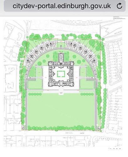
From flicking through some of the bumph, I think they're under the delusion that they are designing Versaille for Louis XIV.
The traffic / transport section (Chapter 7) is from file "13) design + access statement" (last page only) onwards.
The pertinent text is here;
Traffic Management
Cycle Route / Permeability
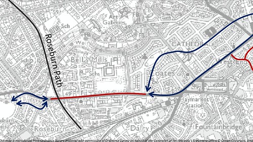
The current consented scheme, as a condition of consent, required the formation of a DDA (grade) compliant cycle / pedestrian link running east - west through the site, entering at the north east corner at its junction with Magdala Crescent / Douglas Crescent and exiting at the north west corner at its junction with Wester Coates Aveneue.
The line of that aspirational route is shown in the local development plan as illustrated opposite.
The practicality and deliverability of such has been thoroughly interrogated through a detailed topographical review of the site at key proposed entry and exit points at north east and north west corners, as well as along the northern boundary edge. The conclusion of such has been that the implementation of a safe / DDA compliant route, without the introduction of significant new infrastructure, is unfortunately technically un-viable. The level differences, between existing external GL’s and the site, particularly at the north west corner are particularly onerous. The northern edge of the site is also made up predominately of infill material at its edge, and near sheer along its eastern half.
The details of such have been the subject of pre application consultation with CEC’s cycle team, and the constraints understood and accepted by all parties. In lieu, an alternative strategy was mutually agreed, with the proposed formation of an access point on the western boundary, with pedestrians and cyclist using and moving through the site in the same way as residents. This was based on acceptance that the most likely route / desire line through the site was from a new western opening to the south eastern corner gate. A new opening to the west would also provide a convenient route for residents of the proposed development to access the Water of Leith path and the Roseburn off-road cycle network. This agreed strategy is illustrated on the plan opposite, with the new access point being controlled by the developments Facilities Management Company, with the gate generally remaining open, and CEC notified in advance of any planned closure. The Management Company would work with Community Police officers and Community Council to monitor use of the access and any associated issues.
Following the agreement and development of this access strategy, it has been brought to the applicants attention that the land strip immediately to the west of the site boundary, previously understood to be in CEC ownership, is in fact in private ownership, making the delivery of this access route, over third party land, un-achievable at present.
The current position, is that the applicant supports this strategy and is happy for the future implementation of such in the event that the land ownership and associated public access right issues can be resolved.
Refer also Appendix. Transport Statement, for further detail.


 posts
posts
