CityCyclingEdinburgh Forum » Debate!

OT: Shetland out the box

(34 posts)

No tags yet.


  1. unhurt
    Member

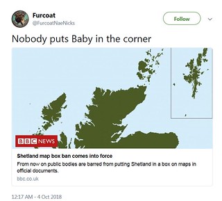
    Ban on putting Shetland in a box on maps comes into force

    The Islands Bill, which aims to offer greater protections and powers to Scotland's island communities, was unanimously passed in May.
    [...]
    Thanks to an amendment from Mr Scott, it also includes a "Shetland mapping requirement".
    The Lib Dem MSP said the common practice of placing Shetland in a box off the Moray Firth or the Aberdeenshire coast was "intensely annoying" to islanders, and created a false impression of the challenges they face on account of their remote location.

    Posted 5 years ago #
  2. acsimpson
    Member

    "However, it does note that authorities can avoid complying with this if they provide "information" about their reasons."

    and

    "...the Ordnance Survey mapping agency, which said inset boxes avoid "publishing maps which are mostly sea"."

    Business as usual for the box drawers then. It seems marginally less robust than the proposed rules for stopping pavement parking.

    Posted 5 years ago #
  3. I were right about that saddle
    Member

    Does the legislation allow maps that leave Shetland off altogether?

    Posted 5 years ago #
  4. gembo
    Member

    the legislation explicitly states

    "an arrow pointing north appended with the words "there be monsters" is sufficient if ye canny fit Shetland in"

    Posted 5 years ago #
  5. I were right about that saddle
    Member

    I mean the USA and Hawaii. France with both St Pierre and Miquelon and Nouvelle-Calédonie. You'd need an actual 3D globe to show them in the right place.

    How about alternate years mainland Scotland goes in the box and Shetland takes centre stage?

    Posted 5 years ago #
  6. unhurt
    Member

    @Iwrats suspect so. Also; Aileen McHarg: "Thank you @ScotParl for providing a new example for teaching literal versus purposive statutory interpretation: would a version of this image with the box around the mainland be in breach of the legislation?"

    Posted 5 years ago #
  7. jonty
    Member

    https://earthobs.wordpress.com/2018/03/20/is-shetland-a-cartographic-compromise-too-far/

    I was convinced this was probably not a brilliant idea by this article. However, as the article suggests, maybe putting the central belt in a box of its own instead is the right compromise if we think a full map is important to emphasise the remoteness?

    Posted 5 years ago #
  8. steveo
    Member

    maybe putting the central belt in a box of its own instead is the right compromise

    Can you imagine the outcry if the central belt were zoomed in and given apparent prominence over the rest of the country!

    Posted 5 years ago #
  9. I were right about that saddle
    Member

    We should really ban Lands End to John O'Groats events if we're serious about this.

    St Warna's Well to Skaw should be compulsory for national unity.

    Posted 5 years ago #
  10. Frenchy
    Member

    St Warna's Well to Skaw

    South Pole to Skaw, surely?

    Posted 5 years ago #
  11. gembo
    Member

    or the Father Ted approach?

    Dougal - this is very small and that is far far away?

    Obviously shrink the rest of scotland and ORkney but keep shtland actual size

    Good that parliamentary time spent on this as I had forgotten how remote Shetland is. Also Fair Isle is virtually in Norway, well ok The Faroes (who beat us at fitba)

    Posted 5 years ago #
  12. I were right about that saddle
    Member

    @Frenchy

    I was going for southernmost road in the United Kingdom of GB&NI. We'd need you or @algo or someone to explain how the South Pole which is a dimensionless point (or is it a line?) can be divided between the eight territorial claims which there converge. What's an eighth of a point?

    Posted 5 years ago #
  13. chdot
    Admin

    Pointless?

    Posted 5 years ago #
  14. I were right about that saddle
    Member

    @chdot

    No the correct answer is 'Two fluid ounces now begorrah'.

    Posted 5 years ago #
  15. stiltskin
    Member

    To be honest, this story brings out a little bit of Tory in me I didn’t know existed :-(

    Posted 5 years ago #
  16. cb
    Member

    "How about alternate years mainland Scotland goes in the box"

    That does seem like a loophole, effectively put Shetland outside the box rather than inside.

    What about the insistence of UK atlases to start at Land's End and work their way, eventually to Shetland, by which time the mapping scale has been cruely dropped down such that it can be squeezed onto one page?

    The OS Landranger series starts at the top and works down, but for some reason they went the other way when they introduced the Explorer series.

    Posted 5 years ago #
  17. dougal
    Member

    Is the preferred alternative a shrunken map? Is that really what this is about - a less valuable map?

    Posted 5 years ago #
  18. stiltskin
    Member

    No. It's about people with a chip a on their shoulder & certain politicians with too much time on their hands...

    Posted 5 years ago #
  19. neddie
    Member

    Does anyone use paper maps anymore?

    <neddie runs away>

    Posted 5 years ago #
  20. steveo
    Member

    No. It's about people with a chip a on their shoulder & certain politicians with too much time on their hands...

    You know thats probably how most people from the South East see the rest of the UK and their representatives. On the other hand it is a silly waste of time.

    Posted 5 years ago #
  21. unhurt
    Member

    You know thats probably how most people from the South East see the rest of the UK and their representatives.

    Indeed. Seem to recall people being - I thought justifiably - narked when BBC weather tilted the map in favour of southern climes...

    Anyway, buried behind North Isles grumpiness is the suggestion that sometimes boxing "created a false impression of the challenges they face on account of their remote location." - and if this seems silly to you, I should note that I've encountered quite a large number of people resident in Scotland who have literally no idea where Shetland is (or indeed where Orkney is, or that they're not the same place). There are probably times when a (relatively - obviously all maps are fictions of a sort) accurate map might subtly inform thinking. Plus people, on the whole, do care quite a lot about how their place is depicted...

    Posted 5 years ago #
  22. stiltskin
    Member

    should note that I've encountered quite a large number of people resident in Scotland who have literally no idea where Shetland is (or indeed where Orkney is, or that they're not the same place).
    I'm not sure that this law will change anything.Under what circumstances are those sorts of people likely to look at the map & say to themselves "Oh, so that's where the Shetlands are!"

    Posted 5 years ago #
  23. steveo
    Member

    , I should note that I've encountered quite a large number of people resident in Scotland who have literally no idea where [Insert Place Name Here]

    The exact location of a place doesn't stop people relating to the problems a place has. I doubt many Islanders appreciate the problems of "inner city residents" beyond what the see on Tagart or Rebus. Blaming ignorance on a map is a bit silly and a total waste of money and whilst we may now all appreciate that Shetland is a "long way away" many isolated rural or small ex-mining villages will literally drop of the map and how will that subtly inform thinking?

    Posted 5 years ago #
  24. unhurt
    Member

    The detail that you can still box her up if you explain why allows for that though - presumably depends on purpose of map / context of use. It's not about random members of the public - central belt or island - appreciating issues in the other location, I think, but about mapping used as one of the tools while developing policy or projects.

    Posted 5 years ago #
  25. steveo
    Member

    but about mapping used as one of the tools while developing policy or projects

    Have you got something in mind?

    I can not envision any situation beyond a sort of general knowledge.

    Posted 5 years ago #
  26. I were right about that saddle
    Member

    Some projections overstate the area of northern regions of course. Could be Shetland's gaining from that.

    I can certainly see why government ministers might want a map big enough to have Shetland in the right place when they're planning national services. Not reduced scale, just enlarged to have the islands in the right place. Is Rockall part of Scotland?

    Posted 5 years ago #
  27. chdot
    Admin

  28. Blueth
    Member

    Reminds me of the visit we once got from our Birmingham - based manager who landed at Edinburgh then listed the sites she wanted to visit, including Lossiemouth.

    When asked if she had arranged accommodation the answer was in the negative: she was booked on the 4pm flight back to Brum.

    Posted 5 years ago #
  29. cb
    Member

    "so that's where the Shetlands are"

    Not sure if it's the same with Shetland but I seem to recall that Orcadians hate having their home referred to as "The Orkneys".

    Posted 5 years ago #
  30. Frenchy
    Member

    @IWRATS - Aye, Rockall is indeed part of Scotland: https://en.wikipedia.org/wiki/Island_of_Rockall_Act_1972

    Posted 5 years ago #

RSS feed for this topic

Reply »

You must log in to post.


Video embedded using Easy Video Embed plugin