CityCyclingEdinburgh Forum » Debate!

Floating Bus Stops

(57 posts)

No tags yet.


  1. Frenchy
    Member

    Are you able to do FOI requests for other council areas or do we find some folk in other cities to do the same?

    You can do FOI requests for council areas you don't live in.

    Sight Scotland wouldn't be FOI-able, I think, but I would hope that a polite email to Mark Ballard is fruitful.

    Posted 2 months ago #
  2. neddie
    Member

    Aye, Sight Scotland yet again manage to conflate two different types of bus stop and tar them all with the same brush.

    "Shared-use bus boarders", which are "paused" in England only.

    "Bus stop bypasses", which are recommended for new designs.

    All of the proposed "floating bus stops" on Dundee St are of the "bus stop bypass" type.

    Also telling that the article has to show an image of a bus-stop-boarder that no longer exists in Edinburgh. And ironic that Sight Scotland then go on to claim:

    [floating bus stops] lack clear kerbs or guidance to tell where the pavement ends and the cycle lane begins
    when it was Living Streets Edinburgh themselves that insisted on at-grade separation of cycle lane and pavement on Leith Walk, contrary to all guidance and recommendations.

    Explainer from Blackford Safe routes:

    https://blackfordsaferoutes.co.uk/jgps-travel-committee/consultation-responses/dundee-street-and-fountainbridge-active-travel-response/

    Archived EEN version, to save you from adding to the manufactured controversy

    https://archive.ph/j86xx

    UK Government recommendations:
    https://www.gov.uk/government/publications/floating-bus-stops-provision-and-design/floating-bus-stops-provision-and-design

    Posted 2 months ago #
  3. bakky
    Member

    From Living Streets Report - an attempted complete (slash completely unnecessary :) typology of bus stop layouts... Ordering is my own, as are some tweaks to names. Click images to embiggen.

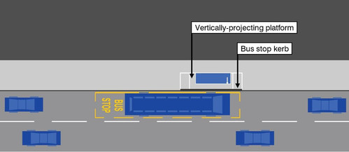
    Type 1: Vertically projecting platform (kerb height raises) - e.g. Loanhead Rd

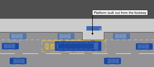
    Type 2: Horizontally projecting boarder

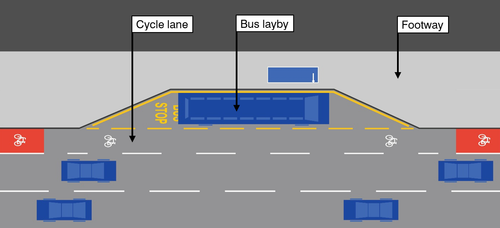
    Type 3: Bus Layby, hope-and-pray lane - e.g. Lanark Rd

    Type 4: Carriageway stop, dissappearing lane - e.g. The Mound

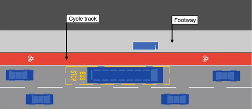
    Type 5: Kerbside cycle track - none in Edinburgh?

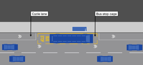
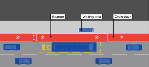
    Type 6: Bus stop boarder - no buffer, raised table) - none in Edinburgh?

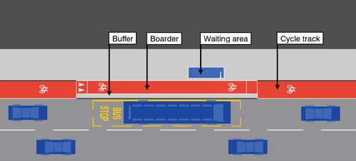
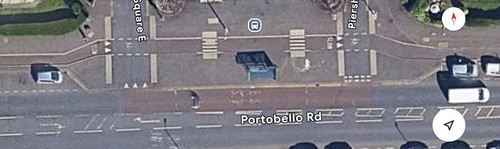
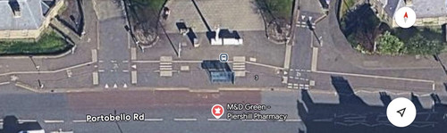
    Type 7: Bus stop boarder with buffer - e.g. George IV c. Sept 2020, or more currently CCWEL at West Coates - though that also features a zebra crossing and tactile paving unlike this illustration.

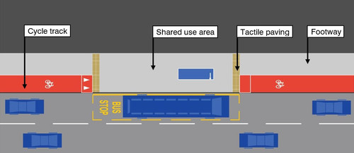
    Type 8: Cycle track at bus boarder - none in Edinburgh?

    Type 9: Bus stop bypass, short island, un-directional cycleway - e.g. plans for Dundee St & Fountainbridge

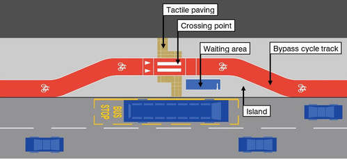
    Type 10: Bus stop bypass, long island, bi-directional cycleway - e.g. Leith Street from Greenside row to London Rd

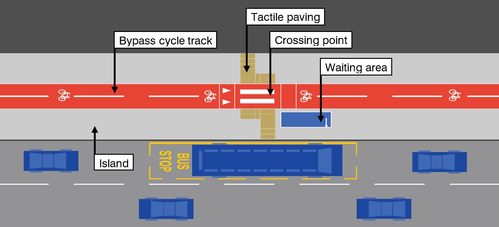
    Types 5-10 are all 'floating bus stops'.

    Dundee St to Fountainbridge consists exclusively of Type 9 Bus Stop Bypasses.

    Posted 2 months ago #
  4. neddie
    Member

    I think there might be a "Type 7: Bus stop boarder with buffer" on West Coates (A8) at Wester Coates Rd, and possibly a couple on the northern end of Leith Walk

    Posted 2 months ago #
  5. bakky
    Member

    (Aside - I know type 2 and type 3 are also in Edinburgh.. just trying to remember examples)

    Edit - type 3 on Lanark Rd (link added above)

    @neddie yes - have updated!

    Posted 2 months ago #
  6. Morningsider
    Member

    @neddie - you beat me to it!

    I suppose it is useful for council officers that most of the objections to the scheme are based on misinformation and misunderstandings. They can easily point out the lanes are kerb segragated, that there is tactile paving where required, and that they don't run through bus stops.

    Also, look at the other photo in the article. The Sight Scotland rep standing on a pavement smashed by vehicles cutting the corner, incorrectly positioned tactile slabs, and most strinking to me - acres of carriageway space that they have to cross to get anywhere. Make it make sense!

    Posted 2 months ago #
  7. bakky
    Member

    I thought that!

    My other thinking regarding zebra and parallel crossings is for how much shorter a period of time it takes to cross a 1.5m unidirectional cycleway for a person with visual impairment (or anyone else for that matter) - compared to time to cross a road. The number of things that have to stack up for there to actually be a user conflict here are staggering.

    Posted 2 months ago #
  8. neddie
    Member

    I suppose it is useful for council officers that most of the objections to the scheme are based on misinformation and misunderstandings. They can easily point out the lanes are kerb segragated, that there is tactile paving where required, and that they don't run through bus stops.

    Aye, it's not the officers I'm worried about - it's the reactionary, badly-informed, and noo-very-bright TRO subcommittee that's the issue

    Posted 2 months ago #
  9. ejstubbs
    Member

    @Morningsider: I think it is remarkable how they managed to squeeze so many references to "fast-moving cycle lanes" into the article. I've seen, and indeed ridden in, a goodly number of cycle lanes in my time and not one of them was going anywhere - at least, not at the time I was using it. For all I know, they could have been ripping themselves up from the foundations of the highway by some means and tearing around sticking their fingers up at speed cameras, racing between cashpoints with their pals and similar antisocial behaviour. But I rather doubt it.

    To put it another way: it's deliberately emotive twaddle.

    Posted 2 months ago #
  10. pringlis
    Member

    The only "floating bus-stop" I know that actually causes problems is the one outside M&S in Morningside which is an island entirely surrounded by road. When the community council put forward plans to pedestrianise that area the same people who complain about floating bus stops said they couldn't support it as, yes, it'd take away the car parking spaces in front of the shops. With many "campaigners" it's not about supporting disabilities, it's just a convenient mechanism for them to object to anything that gets in the way of driving.

    Posted 2 months ago #
  11. Morningsider
    Member

    @ejstubbs - yeah, that did stand out. Alongside:

    Dangerous and life threatening
    Danger
    Fear and confusion
    Stripping away their independence
    Roll them out unchecked
    Daily fear
    Stressful and hazardous
    Putting lives at risk
    Danger zones and an accident waiting to happen
    Unjustifiable
    Clear risks
    Real danger
    Risky
    Strips away independence
    Effectively excludes visually impaired people from society

    You would think it was a strip of landmines rather than a cycle lane.

    Posted 2 months ago #
  12. Stickman
    Member

  13. neddie
    Member

    Archived version of the EEN article above:

    https://archive.ph/09rbY

    Posted 2 months ago #
  14. neddie
    Member

    the council’s own “travel hierarchy” says pedestrian needs should come before those of cyclists

    So close to getting it...

    Can't wait for Whyte to call for cars to be banned, and for everything to be pedestrianised

    Posted 2 months ago #
  15. neddie
    Member

    My teenage son rides independently and has to cross Dundee St several times a week. At the moment he is instructed to use the pavement because entering the carriageway at the bus stop is unsafe. I'd say it's even unsafe for experienced cyclists, as you can't see oncoming traffic past the bus.

    So this is what Whyte is campaigning for - for people to ride on the pavements. How does that help visually impaired people?

    Posted 2 months ago #
  16. chdot
    Admin

    Just come across this -

    City Scope is a modern civic tech platform designed to make local planning applications understandable, accessible, and transparent. Built in Edinburgh, City Scope combines live planning data, AI-generated summaries, and intuitive design to help citizens, professionals, and communities stay informed about how their neighbourhoods are changing.

    https://www.city-scope.co.uk/about

    It seems to be mostly about planning applications but there’s also this -

    https://www.city-scope.co.uk/active-travel

    Inc -

    Fountainbridge - Dundee Street

    UPDATED

    START Jan 2028

    END Mar 2028

    New post about City Scope site -

    http://citycyclingedinburgh.info/bbpress/topic.php?id=21881

    Posted 2 months ago #
  17. bakky
    Member

    I had previously though we don’t yet have any Type 9/10 (see above) grade-separated bus stop bypasses in Edinburgh. However a recent video I saw - from beacon of tolerance and good behaviour Bob Wilkie - there are in fact at least two in Piershill, assumedly leading to very high numbers of people exploding as they use it if the narrative around these is to be believed.


    Posted 2 months ago #
  18. chdot
    Admin

    Isn’t that part of the scheme that ‘just appeared’ without any apparent/normal “consultation”?

    Posted 2 months ago #
  19. bakky
    Member

    As part of the same works that saw kerbed segregation on London Rd, perhaps? I'm not sure.

    Pretty wild to think you can just make safe routes without asking anyone to object...

    Posted 2 months ago #
  20. Frenchy
    Member

    On the other hand, a consultation may have pointed out beforehand that the angles and gradients cause significant problems for handcycles.

    Posted 2 months ago #
  21. bakky
    Member

    @Frenchy oooft. Any resources I could read up on? I recently had an illuminating conversation with a handcycle user but angle (of entry from parallel section into bypass?) hadn't come up.

    Posted 2 months ago #
  22. Frenchy
    Member

    It is a location that was specifically mentioned by a handcyclist I spoke to recently. I'm not sure exactly which points of the lane are the problems, but both horizontal and vertical changes of direction were an issue.

    By horizontal I mean turning circle-related, and by vertical I mean their handcycle grounding out.

    It was a very illuminating conversation.

    In terms of resources, I haven't read it all, or checked whether the Piershill lanes would fall foul of it, but there is Wheels for Wellbeing's Guide to Inclusive Cycling: https://drive.google.com/file/d/1iGQ2MNj9GkdO-hd261JUcFLcQzjZsXvM/view

    Posted 2 months ago #
  23. bakky
    Member

    Thanks! I have heard about grounding out issues at the Telfer Subway ramped steps, but I believe that was relating to cargo trikes and certain recumbant models.

    Posted 2 months ago #
  24. gembo
    Member

    @bakky those ramps deffo raised by @handcycist on here, i think in relation to Roseburn to Canal infra.

    Posted 2 months ago #
  25. Arellcat
    Moderator

    Certain recumbent models includes hand cycles and Edinburgh's two velomobiles (maybe mostly mine).

    The Telfer Subway itself has always been no bueno; the new section from Russell Road to the West Approach Road is technically fine but is ultimately unhelpful because the ramped steps up to Fountainbridge are impassable due to low ground clearance.

    The WAR eastwards from the Toucan crossing is itself fine (but probably illegal) for cycling on, but then there is no access to turn right onto Drysdale Road. The same manoeuverability issues frustrate using the not-really-a-cycle-route past the back side of Fountain Park.

    Back on topic however, the wide turning circle is often more of a hindrance than ground clearance for hand cyclists and velomobile riders, and this precludes right-angled turns beloved of the Leith Walk infra, and necessitates strategic cutouts in segregation kerbs.

    Posted 2 months ago #
  26. bakky
    Member

    Thinking about the subway as a whole - it is pretty dire for a lot of non-standard cycles.

    Approaching from Dalry you've either got a 90° right turn through a stone doorframe and pair of chicanes - to head up and use the WAR toucan — or the left turn at the steps to go up the zigzag. I can do it on the Urban Arrow, but it's barely workable. And that's before you get to those steps.

    So even if they solved the ramped steps, via the rumoured compulsory purchase order and use of adjacent land (ironically from a building owner who has Jacobs, contracted designer for Dundee St & Fountainbridge, as a tenant!), getting to that section still essentially requires users of non-standard cycles to get there solely from either the Dalry Rd or Russell Rd entries to the Roseburn Link.

    A cycleway on WAR eastwards was originally in the link plans but scaled back; I cycled the Drysdale Rd and WAR shared use path for the first time the other day and was amazed by how much space there is 'not path' and dreadful turns.

    I wonder if the handcyclist feedback on Piershill stops is addressed in Dundee St plans for similar bypasses.

    Posted 2 months ago #
  27. Arellcat
    Moderator

    The WAR/Drysdale Road shared use path past the back of Fountain Park is unusable if you cannot (or cannot easily) dismount, because the vehicle access to the undercroft of Fountain Park has no dropped kerbs.

    https://maps.app.goo.gl/8xP8R6CsfmbYfLtJ8

    The Telfer Subway original ramp with the hairpin bend was only just doable on my long wheelbase recumbent bike, by partially letting go of the handlebar to allow it to swing wide on the sharp turn. It cannot be used with the limited turning of a hand cycle or velomobile, and the latter is nearly 3 metres long as well.

    Turns need to have a minimum radius of 6 metres. Tighter than that means 3 point turns at best, just like the ramp up to the NEPN from Russell Road. The zig-zag ramps acessing the Roslin-Shawfair path (e.g. https://osm.org/go/evfgK8mwC--?layers=C&m=) have a radius of about 5 metres.

    Ground clearance can be down to just 5 or 10cm. Plenty of speed bumps are higher than that, but if they are shorter than the bike's wheelbase, you're going to ground out. Those at Dryden Farm, between Manse Road and the Roslin-Shawfair path, are like that (here: https://osm.org/go/eve1B6xHt--?layers=C&m=). Sharp ramps up and down raised tables, especially as were temporarily in place on Geo IV Bridge, are de facto speed bumps.

    Posted 2 months ago #

RSS feed for this topic

Reply

You must log in to post.


Video embedded using Easy Video Embed plugin