CityCyclingEdinburgh Forum » Resources

Dalmeny Estate bike route

(17 posts)

  1. Dave
    Member

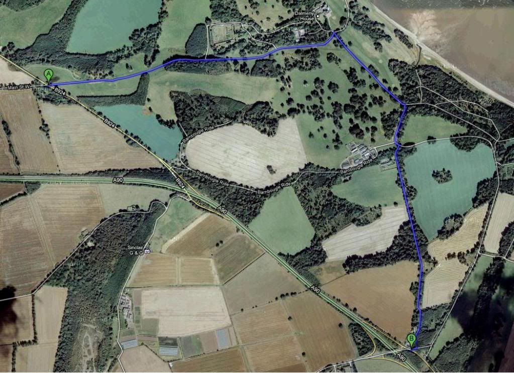
    This morning I rode through the Dalmeny estate on my commute loop, so for reference:

    It's 2.59 miles between the junction with the bizarre "bike gutter" (near Dalmeny village) to rejoin the slip road onto the A90 at Crammond (the road carrying traffic from Kirkliston).

    Took me just under 10 minutes, including stopping for a tractor - and I wasn't racing. There were no potholes, just flawless road surface and the couple of estate cars I passed were very happy to see me.

    In contrast, from a GPS trace when I used to commute to Fife, the A90's 24"-from-oncoming-70mph-HGVs option is 1.55 miles and took 7 minutes.

    There is more climbing on the estate route because you drop almost to sea level, but clearly the time cost is small - just three minutes.

    I strongly encourage people going out this way to have a crack at it, it's *way* better than the official path in every imaginable way.

    Turn off just before the bridge at the top of the slip road (the streetcar doesn't go to the second road, but either of them will do as they both join up 10m in).

    There are a couple of turn-offs to ignore, but follow your nose on the "main" road and you'll eventually get to a junction beside a stream where (bizarrely) there's an NCN sign pointing right. Ignore it and turn left, and you will arrive at Dalmeny house. Bear left to start climbing steadily back up to the junction near Dalmeny, job's a good one.

    Posted 13 years ago #
  2. kaputnik
    Moderator

    I've only ever ridden on the NCN76 bit of the route - and although it's in a lovely setting it's not practical at speed or on a skinny-wheeled bike.

    Will be keen to try this section out as couldn't agree more that the A90-side path isn't pleasant.

    Posted 13 years ago #
  3. DaveC
    Member

    Is this the route?

    http://i126.photobucket.com/albums/p86/Dave_Crampton/Dalmeny_route.jpg

    Dave C

    Posted 13 years ago #
  4. chdot
    Admin

    Sounds good - but not too easy to follow! - "Ignore it and turn left".

    Perhaps you take a few minutes to do a manual trace on http://www.mapmyride.com (or similar).

    UPDATE

    Looks like DC has done it!

    Posted 13 years ago #
  5. DaveC
    Member

    Dalmeny Estate Ride through

    Posted 13 years ago #
  6. Dave
    Member

    I almost rode the route linked above but went out to the right at the end (the dog-leg to the east of the giant "3") because that's the way my nose led me. Looks like you can pull it down by a third of a mile or so going direct.

    The surface is very good - good enough to be comfortable freewheeling down to Dalmeny House at 30mph.

    It comes to mind that I crossed two cattle grids, although they were pretty mild examples. I'd certainly not hesitate with a 23mm slick.

    Posted 13 years ago #
  7. Dave
    Member

    PS. You can see the route I rode on the GPS trace:

    http://connect.garmin.com/activity/70716490

    Posted 13 years ago #
  8. kaputnik
    Moderator

    Good route down to the beach for a sausage sizzle then :)

    Posted 13 years ago #
  9. PS
    Member

    Dave's route is the one I've always taken (with the exception of the section between Cramond Brig and the dogleg road, starts at the gate next to the estate gatehouse and is initially a farm track which can be pretty rough and muddy, but then becomes a decent tarmac job with a nice steep climb up to the dogleg road).

    I've never tried (or indeed noticed) that more direct route. Is it a metalled surface?

    Posted 13 years ago #
  10. Dave
    Member

    The whole loop is surfaced just like this.

    I've ridden out the waterfront way but it's not so useful when you want to ride over the bridge - too slow from the non-surfacing and a giant climb at the end to get up to the toll booths.

    Posted 13 years ago #
  11. PS
    Member

    Thanks Dave - I know the loop that you did - it's a nice bit of road (although heading north you need to watch out of gravel on the two fast 90 degree corners).

    It's the bit of road under the number 3 on Dave C's "Dalmeny Estate Ride through" map that I don't know. Is that metalled?

    Posted 13 years ago #
  12. Dave
    Member

    Ah, I see.

    I think it is, but I'll be able to tell you tomorrow morning. Always on the lookout for a route refinement!

    If only they surfaced the track from Newbridge to South Queensferry... I don't fancy the knobblies necessary to make that a practical choice, but it'd be much nicer than the rat run (even though so far everyone has behaved very nicely).

    Posted 13 years ago #
  13. Its_Me_Knees
    Member

    What are the access rights on the Dalmeny Estate? I assume route 76 must be available to all, but what about the other paths around the estate? Is 76 and the 'waterfront route' one and the same? If so, does that mean that the official bike route is the one with the iffy surface?

    Answers on a postcard...

    Posted 13 years ago #
  14. Dave
    Member

    Conclusion from this morning - it's not surfaced. That makes sense, since I couldn't understand from the map why I hadn't ridden on it. On the ground, the road bears to the left and you can optionally go right onto mud.

    @Its_Me_Knees - it depends who you speak to. According to City of Edinburgh Council and Friends of the Meadows, there are no access rights to the Dalmeny estate whatsoever.

    However, CEC's interpretation of the Land Reform Act is quite... distinctive. I think it is safe to assume that it "does what it says on the tin", and you are free to pass, given that nobody in the last nine years has been taken to court for making the same assumption, anywhere in Scotland.

    Posted 13 years ago #
  15. kaputnik
    Moderator

    The only place in Scotland you can't go under the Outdoor Access legislation is anywhere owned by Ann "gerrofmoiland" Gloag

    Posted 13 years ago #
  16. Dave
    Member

    Kaputnik - you should avoid the 'cycling in the Meadows' discussions!

    Posted 13 years ago #
  17. cb
    Member

    Pre Land Reform, Dalmeny was pretty unfriendly on the whole access side of things.
    Does anyone (chdot?) have a photo of the old sign at Longcraigs listing all the things you couldn't do in or take into the estate (whilst you walked /strictly/ along the coastal route).
    As I recall the list included:
    Dogs
    Cycling
    Fires
    Picnics
    Camping
    Rucksacks (this one sounds ridiculous, but I'm sure it was on there)

    Not sure about Cameras, Children, Stopping, Looking At The View; but there's a good chance they were on the list too.

    Posted 13 years ago #

RSS feed for this topic

Reply

You must log in to post.


Video embedded using Easy Video Embed plugin