@DaveC, a 'turn around' does not equal a 'turnback'.
AIUI a turnback is just a bit of (level) track where it's safe for the driver to head to the other end of the tram.
I have to say, this does all add ammunition to the 'buses are better' camp.
CityCyclingEdinburgh was launched on the 27th of October 2009 as "an experiment".
IT’S TRUE!
CCE is 17years old!
Well done to ALL posters
It soon became useful and entertaining. There are regular posters, people who add useful info occasionally and plenty more who drop by to watch. That's fine. If you want to add news/comments it's easy to register and become a member.
RULES No personal insults. No swearing.

@DaveC, a 'turn around' does not equal a 'turnback'.
AIUI a turnback is just a bit of (level) track where it's safe for the driver to head to the other end of the tram.
I have to say, this does all add ammunition to the 'buses are better' camp.
"I have to say, this does all add ammunition to the 'buses are better' camp"
Indeed.
Just a short conceptual leap to "cars are better".
As has been pointed out by many, Edinburgh's streets are full to capacity with buses. As Jan Gehl observed, Princes Street is just a huge bus station. So, buses are "better": than what? Than nothing?
Just to point out that I didn't actually say that I am in any so called buses-are-better camp, just that tram turning issues do strike me as a bit of a negative point.
E.g. not only can trams not manoeuvre around an obstacle, they potentially can't even back off from an obstacle.
"Just a short conceptual leap to "cars are better"."
I think I'd need some convincing of that.
And the Princes St. bus jam is surely more of an issue with the routing of services rather than buses themselves?
And the Princes St. bus jam is surely more of an issue with the routing of services rather than buses themselves?
I've commented before that Edinburgh's strategic transport plan does seem to be "route everything down Princes Street)
I wonder what will happen when soem numpty parks their car on the tram tracks, like down Haymarket Yards...
It's OK DaveC, if you leave the flashers on you can park wherever you want. It's in the highway code and everything.
In some cities the procedure seems to be for the tram driver to tell the passengers "hold on tight" then ram the car off the tracks.
I really don't understand why the trams need to do a "turnback" at York Place at all. Why can they not just build a loop around St Andrew Sq? Surely less potential for traffic snarl-ups, also no need for any drivers to get out and walk to the other end for the return journey. It doesn't preclude any future line down Leith Walk and might even make it easier to build an even future-er line to the southside as the loop could form a ready made interchange.
Am I missing something?
Why can they not just build a loop around St Andrew Sq?
Am I missing something?
As the line is supposed eventually to go to Newhaven, makes sense to get it a bit further along the route than waste cash on a turning loop.
Some images from "Scotland: Mapping the nation"
http://www.bbc.co.uk/news/uk-scotland-15008220
Picture number 6 shows the Caledonian Railway network. The dashed lines are supposed to show routes 'under construction', but surely many of these only reached the proposed or planned stage?
E.g. was anything ever started along Laggan, or Lochs Tummel and Rannoch, or Glen Shee (that would have been an interesting one)?
It is a superb book.
I'm currently doing the Autumn issue of The Geographer for the RSGS in Perth which has it as the reader offer.
RSGS members also get free admission to many interesting talks. (commercial over!)
Railways...
Laggan no - although that could be a handy cut through to the west and they could have closed that Rannoch bit!
Garve to Ullapool was almost built. I had a map once which showed it as dotted line.
Fort Augustus to Inverness was a proposal.
They did build a branch to Fort Augustus in expectation of running all the way to Inverness up the Glen, but it never performed financially and was an early (1930s I think) casualty, although it remained open for the odd bit of freight and timber use until just after end of WW2.
Killin branch reached Loch Tay, but was always a private railway until nationalisation.
Braemar was reached, but no further.
Ballachullish was reached, but not by the route on the map - the junction was at Connel Ferry, the bridge there being built for the railway. Part of the cycle route now runs along the former trackbed (although not that much of it)
Comrie to Lochearnhead section was completed.
Direct route from Aviemore to Inverness was completed.
I don't think anywhere else on that map in a dotted line was.
Turnback is a generic tramway term - it can be a loop branching off the main route and going around a block of streets or it can be a cross-over between the main tracks or it can be a siding - usually in the middle of the main tracks that a tram runs in to and exits to the other track, usually by spring-loaded points and spring biased conductor wire to avoid any need for actuators.
Those who want to learn more about EGIP might want to attend a meeting local to the site being organised by CRAG on 2nd November London Road Church, 1a Easter Road, at 7.30 p.m
A few other events also on my listing sound interesting - will post in more detail later unless Arellcat or others who are on Lawrence Marshall's mailing list want to mine the listing (from CRAG) for the cycle related nuggets
PS Turnback is a dirty word for cycle-tram track interface issues as it usually means rails crossing your route obliquely on a tight curve and pointwork
"Designs for the point where the tram line will turn at York Place have still not been finalised, it has emerged."
YEP
"
NOT yet designed...
POSTED 1 WEEK AGO
"
http://citycyclingedinburgh.info/bbpress/topic.php?id=3556&page=2#post-41281
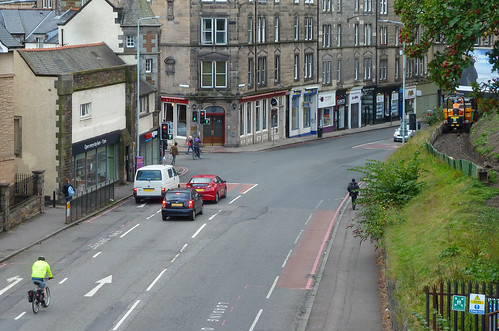
@kaputnik nice map; you've got a wee missing link in Edinburgh - between Baileyfield & Niddry - see the OS Six-inch 1st edition Edinburghshire, Sheet 3 1854: http://maps.nls.uk/os/6inch/view/?sid=74426702
A bunch of the embankment is still present today.
L/
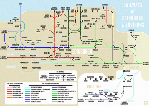 Edinburgh Railways by andy a, on Flickr
In case you were wondering why we have so many railway cycle paths in Edinburgh...
The Pencaitland railway path must continue westward under the bridge at the top of Cowpits Rd, to join up with the Dalkeith to Whitecraig line somewhere.
Would be a nice one to reconnect
The Pencaitland railway path is the alignment of two old railways really; the section from Whitecraig to Smeaton is the "Monktonhall, Ormiston & Macmerry Branch" and from Macmerry onwards was the "Gifford & Garvald Light Railway".
The MO&M branch left the mainline where it crosses the Esk, turning south across the fields, passing the current A1 at a right angle and running parallel to Carberry Road on an embankment, where it crossed Salters Road and joined with the current embankment where the cycle path now starts with the uphill slalom. The northern section of the embankment and the bridge were obliterated in living memory when the road was widened (the line was open to coal traffic until c. 1979)
There was a major junction at Smeaton (the overgrown area around the electric pylons and the travellers' camp) as this was a nexus for East Lothian coal traffic which was collected and washed at a plant just south of the junction. (infact the travellers camp is on top of one of the Dalkeith drift mines).
Anyway, the line curves east here towards Smeaton where the access road for the pylons runs. Now you have to turn right up the hill through the farm and around the bing. The railway ran across the fields around the other side of the bing and under the road at Crossgate, the current road is actually the old railway bridge.
Bridge at Whitecraigs/Smeaton -
http://citycyclingedinburgh.info/bbpress/topic.php?id=15191#post-194060
It would be so easy for them to connect all these routes up along the original alignments and reinstate the bridges. Imagine - a complete railway path from the Innocent to Gifford.
Pretty much all there, apart from -
"
The section through Saltoun Big Wood is easy to follow though
"
https://commons.m.wikimedia.org/wiki/File:Gifford_and_Garvald_Railway._-_geograph.org.uk_-_73614.jpg
In case you were wondering why we have so many railway cycle paths in Edinburgh
Here's one they apparently never built, at least not at that exact location:
The referenced report is fascinating reading, too, in the context of recent months.
Interesting!
Wonder if this was planned to be an extra line or a different routing of the one that was built (and is now the cycle path to the Russell Rd zigzag)?
vaguely on-topic.
I will soon be relocating office into the old Newhaven Station building. Directly above NEPN. Quite excited.
Despite my daydreaming, there will be no Danny Macaskill-esque step-downs off the balcony to get a rolling start on the NEPN.
You must log in to post.

 Cycling in Edinburgh Flickr group
Video embedded using Easy Video Embed plugin
 posts
posts