CityCyclingEdinburgh Forum » Infrastructure

Russell Road to shut(?)

(214 posts)

No tags yet.


  1. chdot
    Admin

    "Whereas the more important motorists already have their 'at grade' bridge across Dalry Rd (on the WAR)."

    Perhaps time some (or all) WAR was buses (and bikes) only - though the bridges are a bit narrow for 'safe' bike lanes.

    Of course there would be 'but that would just move all the traffic to Gorgie and Dalry Roads'.

    Yes, IF nothing else was done to reduce traffic/flow.

    I'm quite sure the WAR wasn't mostly done for the benefit of Gorgie and Dalry residents.

    I wonder when CEC last did a large-scale survey to find out where the 'traffic' goes - free car parks at employers' premises? Shopping? Or just a few miles across town?

    Posted 9 years ago #
  2. cb
    Member

    @eddie_h, that may be true, but the planned route also needs to cross a railway line. Surely they'll put a bridge in for that. Won't they?

    Posted 9 years ago #
  3. neddie
    Member

    Surely they'll put a bridge in for that. Won't they?

    Yes, it will be a single cable with a pulley and a cradle to put your bike in

    Posted 9 years ago #
  4. Fountainbridge
    Member

    I wonder when CEC last did a large-scale survey to find out where the 'traffic' goes

    Edinburgh council know to a large extent where the traffic goes. Many traffic lights have automatic number plate recognition(ANPR) cameras on top of them and they're used to track where and how long vehicles take to travel through the city. When they were introduced it was repeated they were for traffic intelligence rather than crime fighting. Police to not have access to the data.

    The WAR does Darly, Gorgie and Fountainbridge a great service by taking the bulk of traffic away from the areas. I'd hate to see any more restrictions placed on the WAR as it's already close to 50/50 quicker to go through Dalry and Gorgie.

    I wonder if a lightweight bridge could be bolted on to the side of the existing Dalry Road bridge?

    I don't think a new bridge is required to cross a railway line. One of the Edinburgh maps seems to show an existing bridge.

    Posted 9 years ago #
  5. LaidBack
    Member

    Know what you mean about Telford Subway not being an attractive routing to Roseburn Path Eddieh.
    Think the tagged on bridge beside WAR over Dalry Rd is meant to link in with the imaginary cycleway beside WAR directly to Lothian Road.
    Of course this is in the (imaginary?) future when the WAR is jammed packed with 'clean' vehicles silently trying to get into the city. Or maybe a future where less vehicles run in to centre.
    (WAR = Wester Approach Road for viewers just joining us).

    Posted 9 years ago #
  6. Fountainbridge
    Member

    Looks like the shared use path under the Russell Road bridge is now closed.

    The west side footpath is still open though.

    Network Rail have been asked to put up "Cyclists Dismount" signs on the west side following a number of near incidents.

    Posted 9 years ago #
  7. cb
    Member

    "I don't think a new bridge is required to cross a railway line. One of the Edinburgh maps seems to show an existing bridge."

    Got a link? I'm not seeing anything on Google satellite view. @kaputnik and others would know what used to be there if anything.

    With regards to the Telfer underpass, the Council Atlas shows the Family Network route crossing the WAR a short distance (like a few metres) east of the tunnel. I infer this to mean some kind of Toucan crossing approximately between where the bus stops are at the moment.

    But it's hard to tell if this is actually a plan or just a result of someone scribbling lines on a map (in a Simon Parker stylee).

    Posted 9 years ago #
  8. wingpig
    Member

    Not this existing bridge?

    Posted 9 years ago #
  9. chdot
    Admin

    "But it's hard to tell if this is actually a plan or just a result of someone scribbling lines on a map"

    This?

    http://m.cyclestreets.net/journey/#43430102/balanced

    Or the short path to the bus stop?

    Posted 9 years ago #
  10. cb
    Member

    "Not this existing bridge?"

    This is the bit that I think needs a bridge.

    Posted 9 years ago #
  11. cb
    Member

    "This?

    http://m.cyclestreets.net/journey/#43430102/balanced"

    No, I mean, literally right next to the underpass.

    1. Go the atlas:
    http://edinburghcouncilmaps.info/atlas/cecatlas.html
    2. Zoom in to the Telfer underpass.
    3. In the Legend box, expand Transport and select "Cycle Family Network"

    They actually have the underpass marked and and crossing by the bus stops.

    Posted 9 years ago #
  12. kaputnik
    Moderator

    There was a right old tangle of railway lines heading off in various directions around here and crossing eachother at different levels.

    There used to be an at-grade route from Murrayfield (Roseburn) to Dalry Station for the railway, but 2 of the bridges have since been removed. Otherwise that would be a fabulous cycle route.

    The removed bridges crossed perpendicularly across the mainlines out of Haymarket where the the "slalom" up from Russell Road now is.

    The second bridge is that hinted at by cb, crossing the line from Slateford to Haymarket at the wedge of wasteland between the West Approach Road and Duff Street Lane. That bridge was removed when the railway lines were rationalised around Haymarket as I believe a single line had to be doubled.

    If you were to restore this bridge, it would give access from Sauchiebank, across the railway, but you would still need to either cross Dalry Road or drop down and cross the road to get to the path around the back of LIDL (which is the location of the former Dalry Station and loco shed).

    Posted 9 years ago #
  13. Arellcat
    Moderator

    Dalry Rd/Dalry Sta/Duff St/West Approach Road in full layered mappy goodness:

    http://maps.nls.uk/geo/explore/#zoom=17&lat=55.94092&lon=-3.22394&layers=170

    While bike paths and railways ought to be bosom buddies, railways (and big roads alike) are huge obstacles to continuity of routes. You can get an idea of what makes a good route or a bad route by pedalling a torpedo around the city. In the vicinity of Dalry/Fountainbridge/WAR:
    - the Russell Road zigzag is impossible;
    - the Telfer subway is impossible;
    - the marble zigzag on WAR is impossible;
    - Robertson Avenue is steep but reasonably quiet;
    - Henderson Terrace (and on to Dundee St) is too steep when cat and mousing amongst drivists.

    That leaves either Haymarket/Torphichen St or Slateford Road as the only railway/WAR crossing points.

    Posted 9 years ago #
  14. LaidBack
    Member

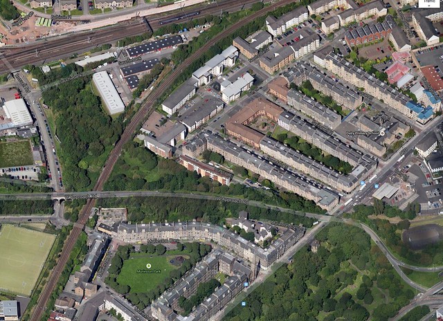
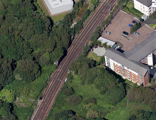
    Can just see remains of bridge here. Lot of green space here - never realised...


    Missing / lost bridge to Russell Road? by LaidBackBikes, on Flickr


    Missing / lost bridge to Russell Road? by LaidBackBikes, on Flickr

    Posted 9 years ago #
  15. cb
    Member

    Thanks kaputnik, arellcat and laidBack for info, links and pics.

    I can't believe I didn't spot the old bridge abutments on Google Earth. Quite a good view of them on Bing Maps, Bird's eye view too.

    Assuming they are in good order then presumably this would make sticking a cycle bridge in a lot cheaper.

    Posted 9 years ago #
  16. Fountainbridge
    Member

    The Edinburgh Atlas seemed to imply a bridge crossing in the top of the photos above. I had a look at google etc but presumed the bridge went under the railway.

    The historical maps shows the bridge crossed over the railway.

    I wonder if Section 75 suff from the proposed developments in Fountainbridge will be used for this?

    Apart from the 2 massive set of steps, the narrow path and the 3 road crossings, what's wrong with the water of Leith walkway connection?

    (I've already lost a day on the Edinburgh Atlas, I'm now going to lose another on the NLS map)

    Posted 9 years ago #
  17. chdot
    Admin

    "Lot of green space here - never realised..."

    Yes, lots of odd corners in many parts of Edinburgh. Satellite view is great for 'finding' them.

    Posted 9 years ago #
  18. fimm
    Member

    Water of Leith path also isn't tarmac. I'd only ride a mountain bike along it. If I am utility cycling, I don't want to get covered in mud, thank you.

    (See discussion elsewhere about whether it should be tarmac (if it hasn't gone to the same place as h*lm*t threads go...))

    Posted 9 years ago #
  19. chdot
    Admin

    @fimm

    Can't find original thread, but a flavour here -

    http://citycyclingedinburgh.info/bbpress/topic.php?id=12085

    Posted 9 years ago #
  20. wingpig
    Member

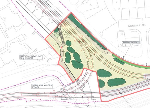
    Maybe this, maybe that, maybe the others.

    Posted 9 years ago #
  21. kaputnik
    Moderator

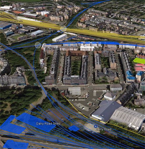
    Dalry Bird's Eye by the Magnificent Octopus, on Flickr

    Current "Roseburn Path" follows the blue line of the old CR Granton Branch coming in at the top right of the picture. It currently terminates at the slalom, rather than crossing the Edinburgh and Glasgow Railway at Haymarket Viaduct (white circle). The white circle below that is the missing bridge across the Haymarket Branch loop line connecting Haymarket to Slateford.

    The West Approach Road currently uses the bridge that crosses Dalry Road. Ideally you would need to build a further bridge here for proper off-road connection to the Canal, but it's more likely you'll end up with a convoluted road crossing.

    Posted 9 years ago #
  22. steveo
    Member

    Any idea why the looped the road through the dalry road shed and not follow the line of the track?

    Posted 9 years ago #
  23. cb
    Member

    "Ideally you would need to build a further bridge here for proper off-road connection to the Canal"

    Edinburgh is serious about cycling. Of course they will build a bridge.

    Ha ha ha ha ha.

    Posted 9 years ago #
  24. kaputnik
    Moderator

    @Steveo I thought the same as I played with the map. All I could think of was that it was cheaper to do that than fill in the site of the old shed, or that perhaps there was some idea to do something more with the wedge of land that the station and shed occupied than a half-hearted play park.

    Posted 9 years ago #
  25. steveo
    Member

    Yeah grand plans as ever, I suppose they'd have had a very large chunk of land between Dalry road and rest of WAR basically inaccessible.

    Posted 9 years ago #
  26. steveo
    Member

    Yeah grand plans as ever, I suppose they'd have had a very large chunk of land between Dalry road and rest of WAR basically inaccessible.

    Posted 9 years ago #
  27. Rosie
    Member

    I commute from Roseburn Street to Fountainbridge. A direct route has been cut by the railway and the Western Approach roads. As the crow flies it's not much of a distance. However every way is circuitous. I usually make it more circuitous and turn right on to Gorgie Road, up Ardmillan Terrace and then on to Harrison Road, Harrison Park and the canal, which is pretty, has least traffic and you're sheltered from the winds which hit you sideways on Fountainbridge. F'bridge is a homage to bad city design in its straightness, the high buildings which funnel the wind and the potholed surface.

    If you go up the path from Dalry Road behind Lidl's you are almost at the level of the Western Approach Road and then you drop again to go through the hideous Telfer Subway.

    How would this work? Continue up the path to the bus-stop on the Western Approach Road. That section of the side of the road could be widened and barricaded so that pedestrians and cyclists could use it to get to the crossing at Morrison Crescent. It would be fairly horrible by the fumy stream of internal combusters but it's short.

    Posted 9 years ago #
  28. neddie
    Member

    Of course if we had a meagre 10% of the total transport budget, there'd be no issue creating the 3 bridges to make the at-grade connection at all

    Posted 9 years ago #
  29. Whilst "enjoying" the quietness of russell road recently, I've been miffed about the position of the contractors huts blocking the dropped kerb to the switchbacks.

    Two weeks of tweeting the council asking for a temporary 'ramp' have just been ignored.

    Maybe karma is on the council's side. Last night a tired/mistimed/rubbish bunny hop onto the pavement resulted in a rear puncture.

    Because of the cold/dark/my bad mood that was a good 30 minute delay to get the tube changed and on the road again.

    Posted 9 years ago #
  30. Fountainbridge
    Member

    I know I'll regret mentioning this but where does the shared path actually start and stop on Russell Road?

    I'm sure at one point the shared path extended from the Roseburn junction to Sauchiebank. There's still faint pavement markings on the pavement of Roseburn Street (https://goo.gl/maps/5Z6kl).

    As a side issue the switchback doesn't meet the approved planning approval. I've not found a planning app that supersedes this design

    https://citydev-portal.edinburgh.gov.uk/idoxpa-web/applicationDetails.do?activeTab=documents&keyVal=JR1JDOEWW1000

    Russelroad-zigzag by fountainbridge, on Flickr

    Posted 9 years ago #

RSS feed for this topic

Reply »

You must log in to post.


Video embedded using Easy Video Embed plugin